So I checked the situation here in Bavaria (well, sometimes they run conform whith German policy, sometimes they insist on their federal sovereignity - at least when it comes to surveying… btw - have you ever read Kafka? “Landvermesser K” … very revealing… ![]()
![]() … any way…)
… any way…)
There were “lateral fix points” on a per municiality level in thte past. Labelled as “not activeley maintained any more”. Visitied two of them, close to my fields. Both where gone.
There are many “elevation fix points”. Even surveyed in ETRS89_UTM32, but only at 6 cm accuracy.
What they say to maintain are “geodetic reference points” on a per “Landkreis” (county?) level.
The next one is 13 km from my base.
So I went to the spot and took readings with my poor-man’s-survey stick.
Happy that I designed the stick to fit in my ![]() top case
top case ![]() .
.
The results look impressive, in my eyes:
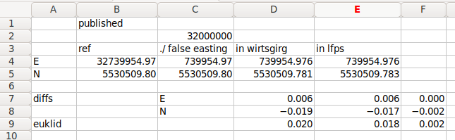
Column B are the published coordinates (in ETRS89:UTM32).
Note that they are given only in cm-level precision.
Column C substracts “false eastings” as assumed from the UTM system (just educated guess, but happens to work out).
Column D are with RTK correction signals from my own base station.
Column E are with RTK correction signals from official LFPS service, supposedly running at the current offical refrence system ‘ETRS89/DREF91 (R2016)’.
Line 9 is the euclidian difference of measurements in mm:
- The deviation of my measurement (D/E) from the published ETRS89 coordinates (C) is < 20 mm.
Note that the values are given in cm precision only, anyway. - The deviation between ref to my own base and public LFPS (C vs E) is 2 mm (Cell F9)
Hitt the spot, ![]()
![]() I’d say.
I’d say.