Radio short range with line of sight. Good old way of portable RTK base you stick it into ground wait few minutes to survey it self, and then connect like normal. You dont get static AB lines but relative is nominal 2.5cm ± accuracy.
We have just had a drainage scheme installed by a contractor using a trimble system on the mastenbrook drainer the base station used was mobile with radio , we only had to make a permanent location for the base so that it could be removed at night and reinstalled the next day, accuracy on the three planes was in mm accuracy, hopefully this might help
1 Like
Well, always hit for a home run! I had a nice chat with one of my close by neighbors about rtk and he said we all start backwards, correcting the sprayer first and then the seeder. If your rows are perfect, you can use them for spraying, and now I’m hooked on seeding tramlines! Just sounds like the best place to start( and then my 'even more than me, technology retarded brothers ', may just help me spray some times)
So yes, I want the full package
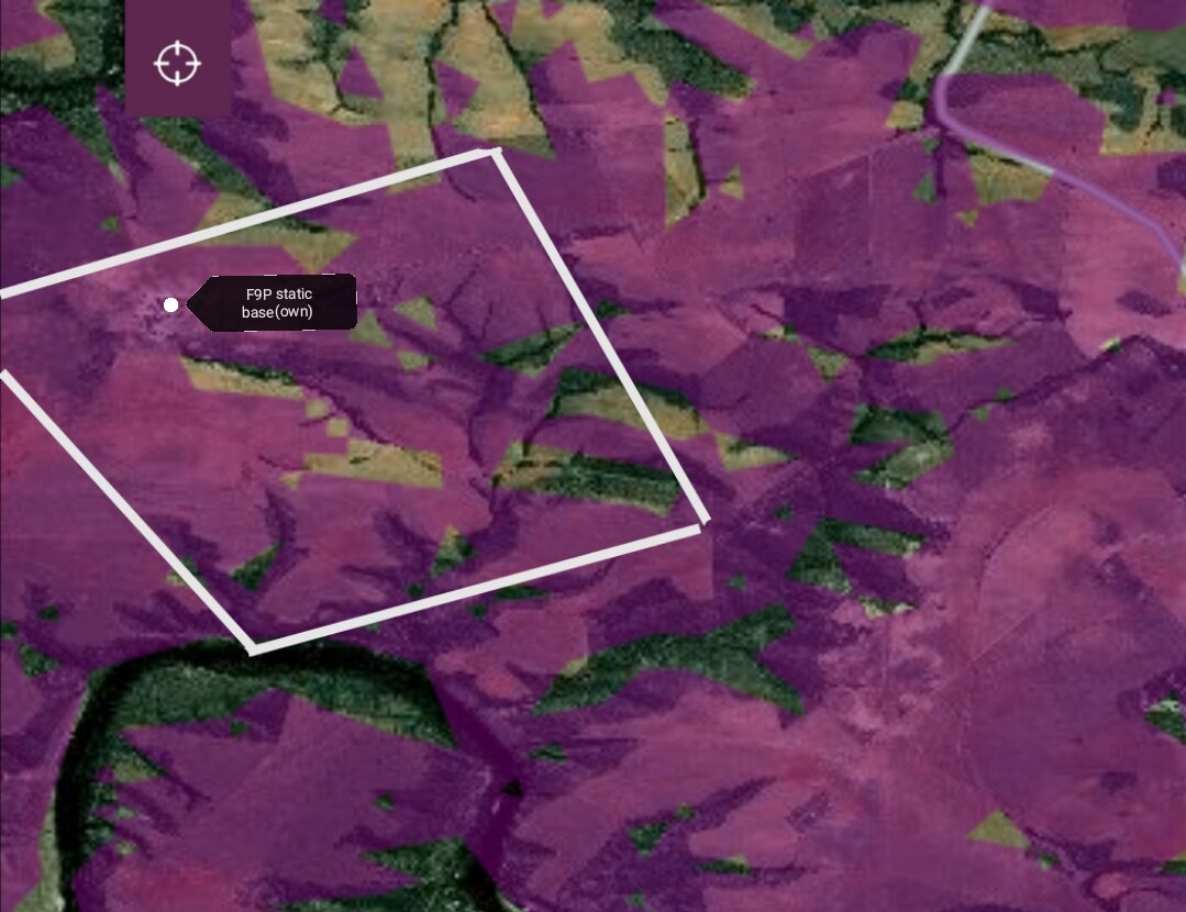
Fields are all smaller than 120 acres and will all be closer than 2km from base(static)
I’m willing to start of with portable repeater base in between static base and rover (if it’s a possibility),but honestly, there’s no time for moving base, so if it works, I’ll make repeaters static to, (solar).
Ardusimple RTK-SSR
This looks same principle as ublocks L5 service that PotatoFarmer mentioned, but I would want rtk.
u-blocks PointPerfect
Okay, so would this mean that one could NTRIP where possible and L5 in the mobile dead spots? That sounds decent enough?
![]() If you look at rtk2go and AOG distribution maps, you’ll see South Africa is as good as being on Mars! No luck for NTRIP Caster nearby, I’ll have to be the first one
If you look at rtk2go and AOG distribution maps, you’ll see South Africa is as good as being on Mars! No luck for NTRIP Caster nearby, I’ll have to be the first one
The complete AOG setup without annual subscriptions is cheap compared to commercial brands,but still expensive enough to have to be very sure i’ll (we) be able to make it work before investing.
I want to COMPLETELY free myself from any commercial product
My neighbor installed a trimble autosteer in his seeding tractor and to my disgust he had to pay for another correction signal even though he has the same setup in his sprayer!! No thank you, please get me some

Okey so since I have 4g cell coverage almost everywhere, I think it’ll be best to start there and see how far a Wilson booster will help me (thanks Keegan4123). Wish i could borrow one somewhere to test first, they are also not that cheap ![]() .
.
1 Like
The easy version on year to year repeatability is if your base location does not change, and your entered base coordinates for that location do not change at all. You will be forever accurate to the benchmark the base is on.
So find a good spot and put a sturdy permanent mount point that you can thread the antenna onto, then whatever you use for base coordinates, write them down you will need to re enter them. If you are moving the base around a lot you will need to record a few.
When you come back the next time, thread onto your benchmark, enter the coordinates and you will be in the exact same spot.
Think of the base station coordinates as the corner of a grid the rover can move on, if you move the corner, or change the coordinates for it, the whole grid moves with it. That causes the rovers position to shift an equal amount as well.
2 Likes
Thanks, very well explained.
Can the f9p change to L5 when it loses rtk?
What minimal specification does a radio need to be able to send f9p’s GNSS messages?
The L5 corrections would be a paid alternative to rtk. Still do not know F9P’s behaviour with it as no one has tried it yet. Its new!
Ardusimple has Lora radios meant to be used with them. They are a low cost line of sight data radio. The data transmission rate needed is very low, depending on how many corrections are used. 100kb/s or less.
More expensive alternatives with higher power are scada radios like ge’s mds system. Or high power omni directional wifi system from Ubiquiti.
If cellular is only marginal, I would try seeing if a booster would work.
1 Like
Why I’m asking the specific requirements, I spoke to a guy who is in the radio coms of emergency service’s etc, in my region, and his willing to find out what my options are. They have base stations on top of the mountain and reach for 100s of km. Need to sound as if I know what I’m talking about😉
Bet I would have to pay for a frequency or something, but it’s worth the effort
Almost impossible to propose any best approach for RTK correction data without very accurate understanding of local conditions. A typical solution is one of these (match the frequency allowed locally):
and install it at a very high position. Needs licence because of the transmission power. Still cheaper than building your own internet.
These high power radios work further than the single base RTK signal is useful as long as the terrain is favourable. But if you have a huge mountain between the base and the field, you need repeaters or some other solution.
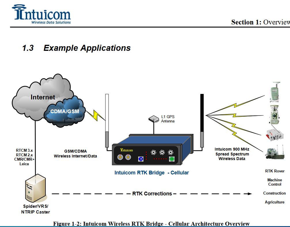
If the cellular coverage is patchy but exists at a decent distance from the field, you could use a cellular NTRIP to low power radio (free of licence) RTK correction signal repeater. No hassle with portable base coordinates.
1 Like
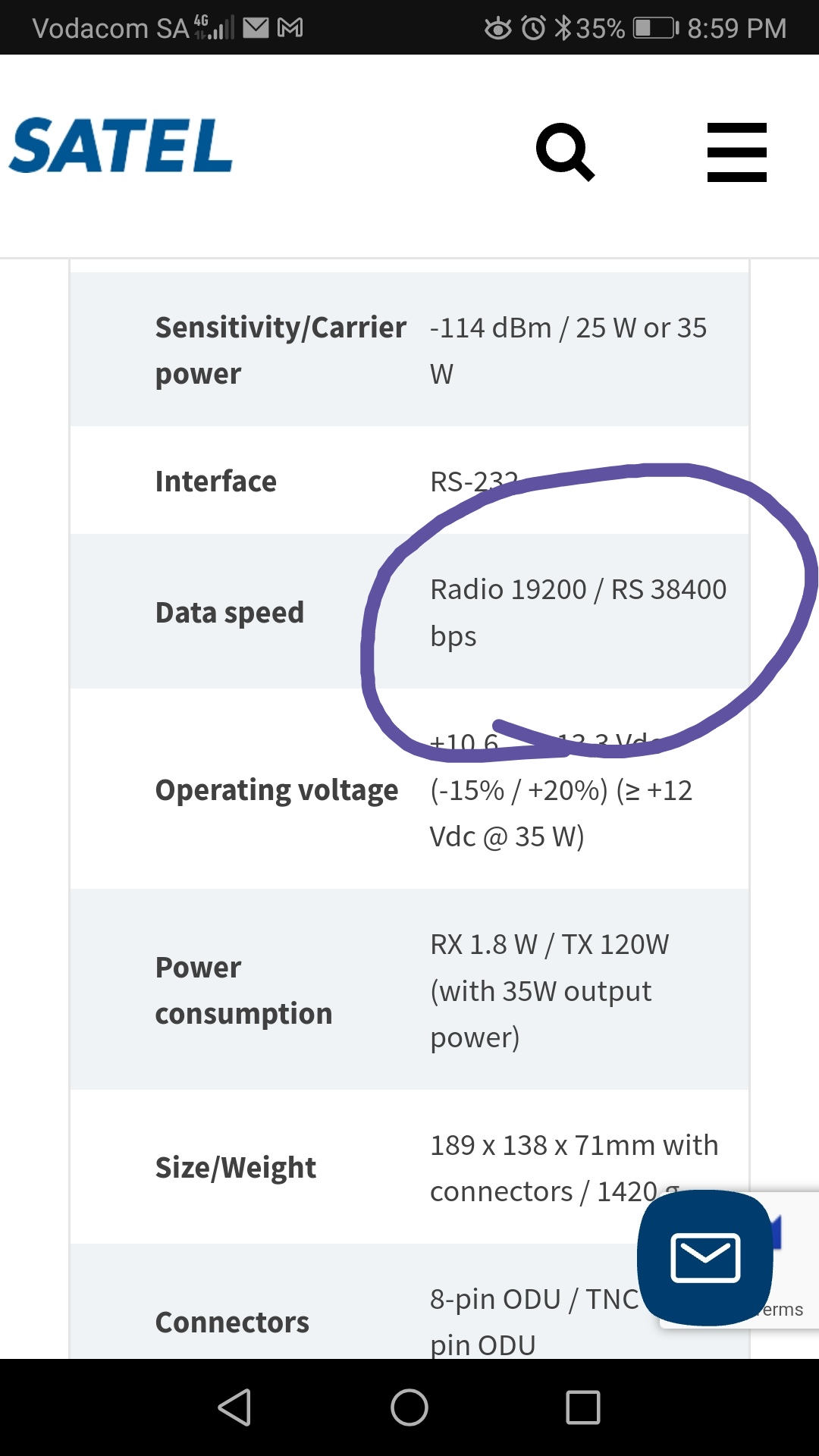
The screenshot is of the SATELINE EASy Pro, looks way less than 100kb/s?
As you can see I’m a tractor driver and know next to nothing about this stuff, but I’ll get there.
I’m going to email these people now to see how they are set up, I’m pretty sure they have a rtk setup running for vehicle tracking, maybe that would be useful for me, to an f9p in tractor?
Are you saying that one can run cellular NTRIP over radio to tractor, also? Very interesting, how ever in South Africa crime/corruption is so completely out of hand, and power cuts, together with theft of the backup batteries at cellular towers, has and will always make my internet connection unreliable, so I must look for alternatives
If you want to use GPS, Glonass, Galileo, and Beidou, you probably need at least 38400 bps. 19200 might work fine for just GPS and Glonass.
As for the long range stuff, there are several issues at play here. Obviously there is licensing. But longer range transmissions usually mean longer wavelengths (lower frequencies), which also means much less bandwidth. So their tower that transmits 100 km most likely is a lower frequency than 900 MHz, and not capable of enough data. Under ideal circumstances, 900 MHz can broadcast 110200 bps for around 30 km, line of sight with no obstacles and good antennas at both end.
How far are you from this location where these long-range towers are located? If it’s not too far, then a repeater could work. You generate the rtcm data stream and transmit it over 900 Mhz towards the tower from your base station. On the tower, a 900 MHz receiver picks it up and re-transmits it over 900 Mhz on a different channel, which your rovers are tuned to. At one time I thought about setting up a repeater on my farm to get signal over a hill on the edge of farm. But since I had cell coverage everywhere I figure I’ll just use cell when working that field. I can toggle between bluetooth and radio with a switch in the cab.
The need for all four GNSS constellations also depends on the environment, how good is the sky view at each field? This is not the same as visibility to the radio at the GNSS base.
My older GNSS base (Novatel) supports GPS and Glonass only and the correction data stream is less than 2700 bits per second. Our OEM Fendt radio (also a Satel modem) used to run at 4800 bit/s max speed and it was obviously fine (a Topcon dual constellation receiver). Even this RTCM stream can be optimised, running most messages at a lower speed except RTCM 1004 and 1012. Better to have GPS and Glonass corrections only rather than no RTK correction data at all. If the fields have decent sky view, GPS + Glonass is more than sufficient, even GPS alone would work.
At good conditions this Satel modem (or any other similar modem that is popular for radio based base stations) reaches 100 km range which is way more than the useful range of RTK corrections from a single base.
Having said this, I’ve only used radio out of interest. In practise always use NTRIP over cellular because we have absolutely perfect cellular coverage on every field.
Clarifying the question about radio corrections versus NTRIP, the two are just a transport approach and the actual payload is exactly the same RTCM data stream. Odd that this is questioned so often at the forum.
Google earth it’s 45 and 14 km. I’ll have more info later
I see darrenjlobb has I good setup with airmax radio’s +repeater where no line of site.
I know this, but I’m trying to figure out what you are referring to here:
The “cellular NTRIP to low power radio repeater” receives RTK correction data through cellular connectivity and then transmits the same data with a radio modem. Just like a radio repeater but cellular connection replaces the first radio link of a radio repeater approach. The device is an NTRIP client for the caster at the base and then transmits the correction data just like a radio would do at the base (but at lower power which should mean no need for a radio licence at all).
Every repeater approach has some drawbacks too. A mixed approach means the rover should have a radio and should be able to use cellular connectivity too, perhaps via the driver’s personal phone.
PS. I’m still confused about the complete scenario. Earlier on you mentioned fields are only 2 km from a static base. Is this a planned base site for your own base? 2 km should be nothing for a low power unlicensed radio unless there are big obstacles in-between the base and the rover (mountain). If there is, a low power to low power unlicensed radio repeater might work well.
Also lost with the long range towers, how come 45 km away if the fields are 2 km away? Or are these free RTK2GO sites. A hand written map would clear things up.
These are government owned towers for there radio network.
Exactly right, if the government bases is a no-go, my homebuilt static base (with 4G coverage) would be within 2km of the furthest fields, but these fields do not have cellular coverage nor line of sight from base.
What is an example of such a device, and can one not build repeater for the cellular network itself, to get it into the dead spots, if a booster is not good enough?
1 Like
Thanks for all those clarifications.
Now I’d like to understand how severe is the obstruction blocking line of sight view? I’ve run a 1W base radio at the 400 MHz range with the antenna inside my (wooden) garage at less than 7 metre height and reached easily 5 km range with no line of sight view. Some foliage, small forests in the way, no high mountains.
Considering the NTRIP to radio repeater, there are several commercial products but I’d build one from a GPRS modem and a commercial radio.
I did some tests with LoRa radios, and it looks very promising, I still have to test more
https://discourse.agopengps.com/t/questions-about-lora-radio-915mhz-and-gps/8132
1 Like
This is a map of 4G Internet coverage on farm, the spots that are not purple coloured are dead spots and they are a bit broader than that.
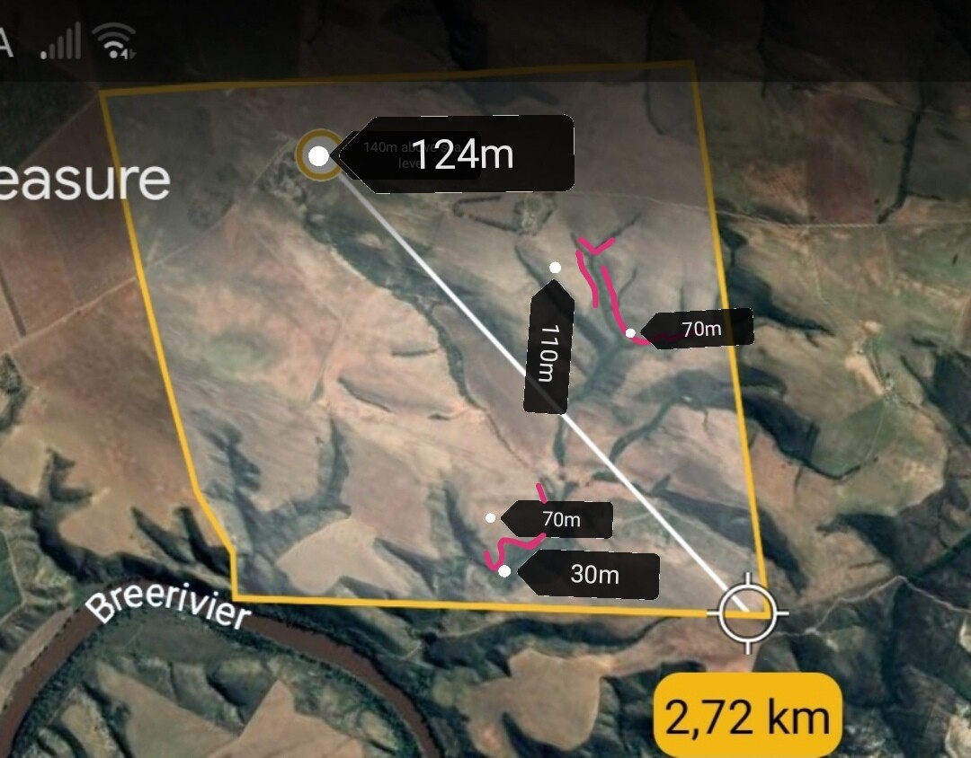
This is above sea level. At 124m will be my base.
The pinkish lines are the low spots and then there are hills between them and base.
1 Like
Thanks for the reply, have you done any auto steering yet?
These lora radio’s are cheap enough to give try regardless
Another possibility for you is this: https://www.ardusimple.com/rtk-ssr-corrections-from-space/
Seems like this is not an option in the southern hemisphere?
some good news since NTRIP is already available.