I like experiments
No. Should I?
What’s this?
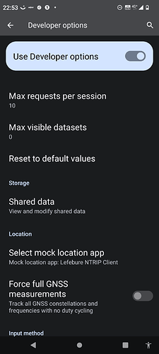
I think so. Did you go into developer options and select a mock location app?
Well, I think my phone did. But could be different. All looks good.
You know if this fix make rtk work for all mobiles, or do they need special hardware for it to work?
Hmmm? This combined with your 3 m accuracy mentioned above, make me think you use the GPS receiver in the phone?
But to get real RTK precision you need an external receiver (could be an F9P with a Bluetooth device like hc05 as shown above ) And the NTRIP from a base, via lefebure.
The Lefebure app sends corrections from base via Bluetooth to F9P, and at same time receives GPS signal via Bluetooth from f9p. Hopefully as corrected RTK ![]()
I have a 10 year old Samsung mobile and the mock function work fine.
I don’t know if new phones have a gps chip that is capable of doing rtk calculations.
Just because you are pulling in ntrip data does not mean that you have an RTK Fix, it does not even mean that you have a GNSS receiver that is capable of RTK.
I can’t imagine that any normal phone has a built in GNSS receiver capable of RTK. You’d need to use an external receiver if you want RTK.
I don’t know what kind of H an d V accuracy I have, but only the last decimal point moves when I hold the F9P stationary.
Oh sorry for not clarifying that! I assumed an external receiver was being used… Thanks Larsvest and Wildbuckwheat
You are in my area…
Thanks for clarifying that.
I’ll go shopping then ![]()
Correction data (rtcm3) as a hexadecimal string.
