so, what’s the easiest way to use the software?
Export only one route per machine, and for example import 3 time curve in the agopengps?
This time I had exported 3 machines in one file.
Why should I use curve when there is only 1 route?
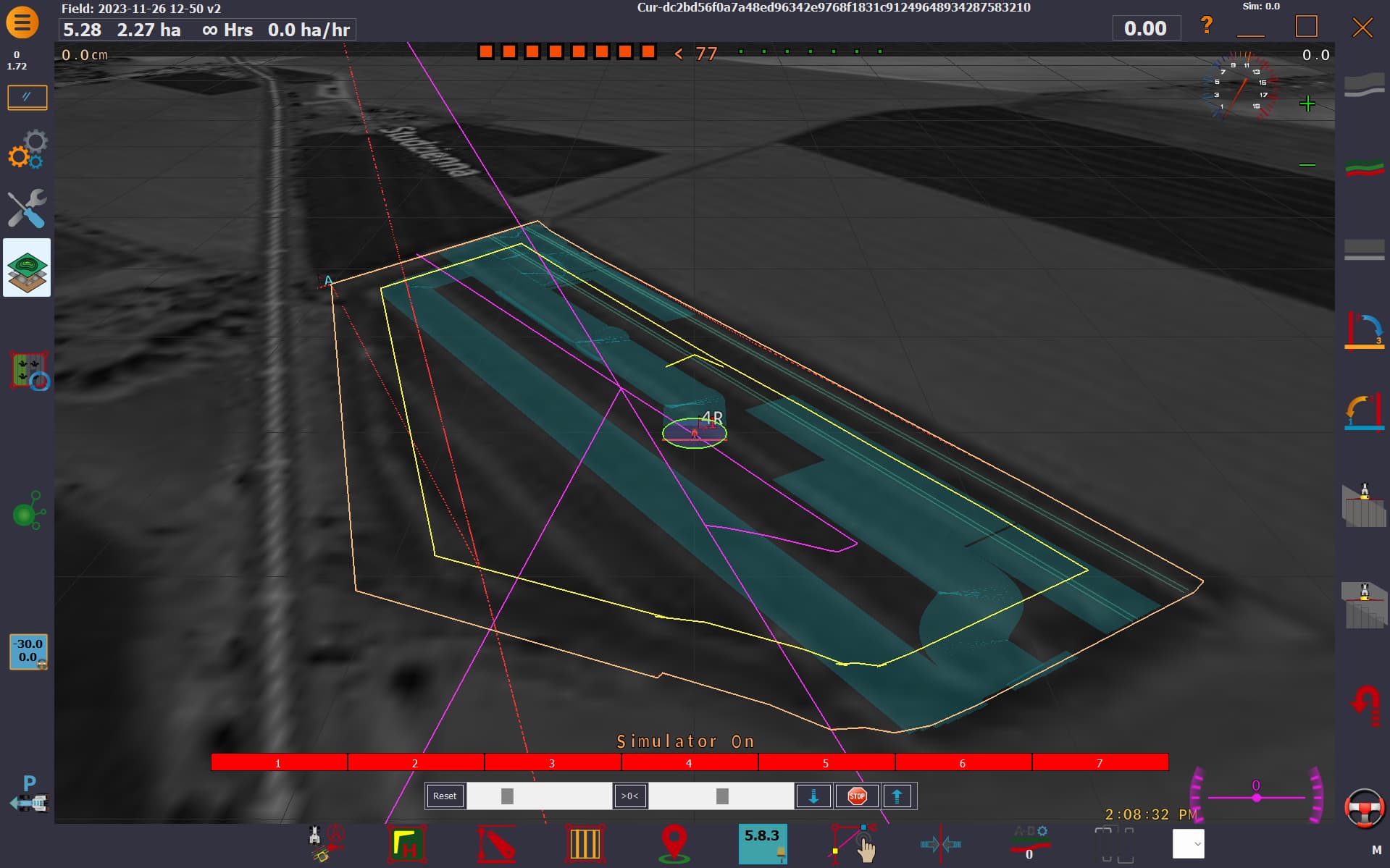
here is the import in AOG
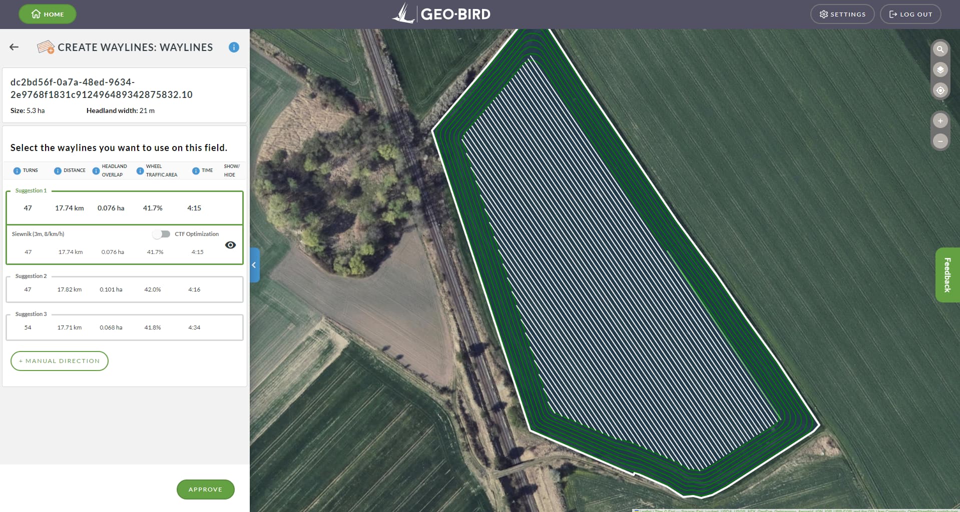
and here is the source in the geo-bird
and file for this `<?xml version="1.0" encoding="UTF-8" standalone="no"?>
dc2bd56f0a7a48ed96342e9768f1831c91249648934287583210
Boundary
BoundaryStyle
0.0
5
1
clampToGround
16.454928806480698,50.90609948350854,0
16.45552433752856,50.90654012305432,0
16.456052419424232,50.90695194996332,0
16.456172388982946,50.906798947221425,0
16.456555320303064,50.906423526947115,0
16.45705786145309,50.9059554382737,0
16.45755140938282,50.90549233549482,0
16.457979126940003,50.905122916137124,0
16.458302523141768,50.904826879473084,0
16.458635272292643,50.90453492422969,0
16.45908115615482,50.90410708285774,0
16.459016944561917,50.90406398091087,0
16.45809154219367,50.90368978627923,0
16.45793218233006,50.90363432037467,0
16.457814910737422,50.90361458402457,0
16.457727136907362,50.903628989292415,0
16.457622995416365,50.90362309107305,0
16.457442771281663,50.9036928488119,0
16.457103726876586,50.903787220090685,0
16.457088977995312,50.9037713403216,0
16.455979394475435,50.90406999250061,0
16.454928806480698,50.90609948350854,0
16.454928806480698,50.90609948350854,0
Set_261123_siewnik3
WaylineStyle
0
2
2
0.0
1
1
clampToGround
16.456409269,50.904149802,0
16.455374233000004,50.906149289,0
16.459795943542133,50.89760614323437,0
16.451986318615525,50.91269280979937,0
  <IconStyle>

    <Icon>

      <href>http://maps.google.com/mapfiles/kml/paddle/A.png</href>

    </Icon>

  </IconStyle>

  <BalloonStyle>

    <displayMode>hide</displayMode>

  </BalloonStyle>

</Style>
<Style id="PaddleB">

  <IconStyle>

    <Icon>

      <href>http://maps.google.com/mapfiles/kml/paddle/B.png</href>

    </Icon>

  </IconStyle>

  <BalloonStyle>

    <displayMode>hide</displayMode>

  </BalloonStyle>

</Style>
<Style id="PaddlePlayGreen">

  <IconStyle>

    <Icon>

      <href>http://maps.google.com/mapfiles/kml/paddle/go.png</href>

    </Icon>

  </IconStyle>

  <LabelStyle>

    <scale>0</scale>

  </LabelStyle>

</Style>
<Style id="PaddleStopGreen">

  <IconStyle>

    <Icon>

      <href>http://maps.google.com/mapfiles/kml/paddle/grn-square.png</href>

    </Icon>

  </IconStyle>

  <LabelStyle>

    <scale>0</scale>

  </LabelStyle>

</Style>
<Style id="PaddleCircle">

  <IconStyle>

    <Icon>

      <href>http://maps.google.com/mapfiles/kml/paddle/red-circle.png</href>

    </Icon>

  </IconStyle>

  <BalloonStyle>

    <displayMode>hide</displayMode>

  </BalloonStyle>

</Style>
<Style id="Caution">

  <IconStyle>

    <Icon>

      <href>http://maps.google.com/mapfiles/kml/shapes/caution.png</href>

    </Icon>

  </IconStyle>

  <BalloonStyle>

    <displayMode>hide</displayMode>

  </BalloonStyle>

</Style>
<Style id="Pushpinff0000">

  <IconStyle>

    <color>ff0000ff</color>

    <Icon>

      <href>http://maps.google.com/mapfiles/kml/pushpin/wht-pushpin.png</href>

    </Icon>

  </IconStyle>

  <BalloonStyle>

    <displayMode>hide</displayMode>

  </BalloonStyle>

</Style>
<Style id="Pushpin0000ff">

  <IconStyle>

    <color>ffff0000</color>

    <Icon>

      <href>http://maps.google.com/mapfiles/kml/pushpin/wht-pushpin.png</href>

    </Icon>

  </IconStyle>

  <BalloonStyle>

    <displayMode>hide</displayMode>

  </BalloonStyle>

</Style>
<Style id="Pushpin00ff00">

  <IconStyle>

    <color>ff00ff00</color>

    <Icon>

      <href>http://maps.google.com/mapfiles/kml/pushpin/wht-pushpin.png</href>

    </Icon>

  </IconStyle>

  <BalloonStyle>

    <displayMode>hide</displayMode>

  </BalloonStyle>

</Style>
<Style id="Pushpinffff00">

  <IconStyle>

    <color>ff00ffff</color>

    <Icon>

      <href>http://maps.google.com/mapfiles/kml/pushpin/wht-pushpin.png</href>

    </Icon>

  </IconStyle>

  <BalloonStyle>

    <displayMode>hide</displayMode>

  </BalloonStyle>

</Style>
<Style id="Pushpin000000">

  <IconStyle>

    <color>ff000000</color>

    <Icon>

      <href>http://maps.google.com/mapfiles/kml/pushpin/wht-pushpin.png</href>

    </Icon>

  </IconStyle>

  <BalloonStyle>

    <displayMode>hide</displayMode>

  </BalloonStyle>

</Style>
<Style id="AreaObstacleStyle">

  <LineStyle>

    <color>960000ff</color>

    <width>1</width>

  </LineStyle>

  <PolyStyle>

    <color>960000ff</color>

  </PolyStyle>

  <BalloonStyle>

    <displayMode>hide</displayMode>

  </BalloonStyle>

</Style>
<Style id="BoundaryStyle">

  <LineStyle>

    <color>ffff0000</color>

    <width>2</width>

  </LineStyle>

  <BalloonStyle>

    <displayMode>hide</displayMode>

  </BalloonStyle>

</Style>
<Style id="WaylineStyle">

  <LineStyle>

    <color>ff0d9eda</color>

    <width>2</width>

  </LineStyle>

  <BalloonStyle>

    <displayMode>hide</displayMode>

  </BalloonStyle>

</Style>
<Style id="WorkedAreaStyle">

  <LineStyle>

    <width>0</width>

  </LineStyle>

  <BalloonStyle>

    <displayMode>hide</displayMode>

  </BalloonStyle>

</Style>
Aog is not built to direct import from kml. The kml reader is for individual components. Boundary and curves only. And one at a time. GeoBird appears to save the lines as A,B,A extension,B extension. As I drew the picture, they are out of order for a line or curve. I have not looked at the boundaries to see what order they are written in. But per your picture, they are out of order as well. That is why all the excess purple lines.
You asked why use curve when it is only a line, because geoBird and trimble use multiple points to store a line. AOG uses two. A line is just a very simple curve. In the latest version, all lines are treated as curves, and all curves as short lines. That is how the program is reading them. They are not far from just calling them all paths. No lines, curves, or contours.
The kml reader for the curves has been added very recently into the main program. Up until now it was just a hack to add them. There is some interest in converting all of AOG to be kml based, but then you are at the mercy of the current kml version. Txt files don’t change. AOG development strives very hard to maintain compatibility with some of the first fields created in the older versions.
thanks for Your explanation.
Can You recomend some free tool - online or desktop aplication to manage kml files to one line per one file? To easily convert GeoBird files into agopen or even Trimble?
No, I don’t know of one. I typically use Google earth and just click individual components and save as. But that will not fix a line that is drawn out of order. It will display correctly in GE but useless in AOG.
so, how to fix the line to get it correct for AOG.
Even I have line, when I save it in GE pro - windows version, when I open curve in AOG it looks crazy
1 Like
no I did nothing but once more exported from Geo-Bird.
How to find which point should be moved?
I pasted each lat and long into GE and found that number 3 was out of order. When you paste them you have to reverse the coordinates stored in the kml or you will be in the middle of a desert.
OK, got the idea.
Probably the last question, is it somehow possible to prepare kml file to be understand by AOG as an AB line?
Yes it is possible. Just a bit of programming. Just go through all the points and find the two points that are farthest away from each other and build the line off those points.