Hey just joined ! I accidentally came across this site and great amount of information / people, wow ! Can’t even believe people/farmers are helping each other out , thought my only option was to shell out another 15 grand for a fancy new Trimble unit that will be obsolete in a year , and stuck paying fees for mediocre accuracy.
Very interested to get starting building a unit .
Of course will have a pile of questions ,
Welcome! Yes the fees from trimble are what brought me to agopengps. Have been using agopengps for many years now. Feel free to ask questions. What part of SK are you from? If your lucky enough you will be close enough to someone with rtk base station.
Up by Blaine lake , ya realistically for the price I’d be interested in having my own . Is it possible to have a base I can move , let’s say 100 miles away and set it back up without to much hassle ?? It would be handy if you’re doing custom work far from home .
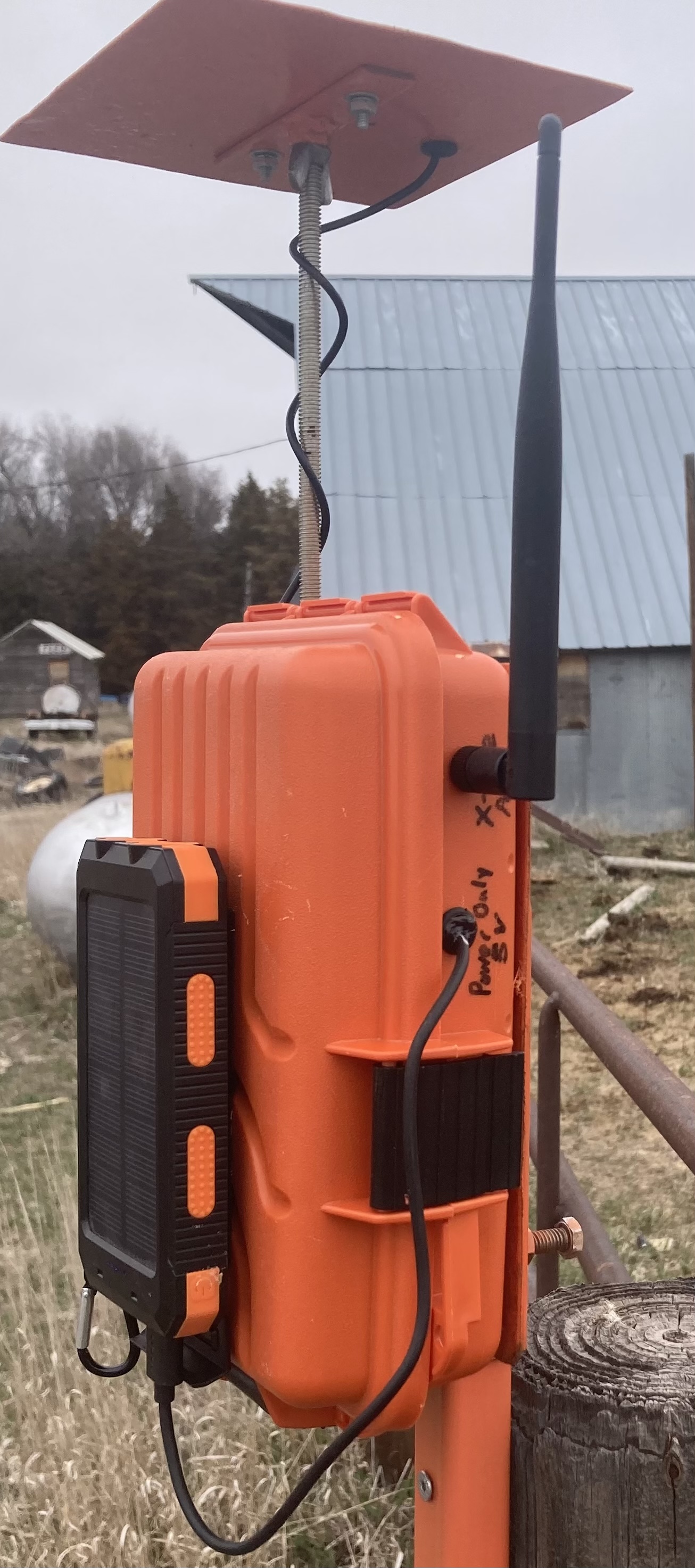
The bases that I have set up use the auto survey in functionality of the F9P so you just have to power it up and let it run for about two or three minutes and you have RTK. Couple that with the radios and you have a easy to use base that can be moved around
So the part I’m not understanding , how is the base and vehicle actually talking to each other ?
Keeping in mind no wifi and very poor cell service area .
You would probably want to use 900 MHz xbee radios. Basically you will have the base station with a F9P set up as a base with the serial interface connecting to most likely an XLR XBee(Extra long range) that will transmit your RTK data. On the rover you will have a LR Xbee(Long Range) that dumps the serial data to your receiver on the tractor. The one on the tractor doesn’t need to have the extra power of the XLR since it never transmits.
This is what I do as well, I power it with a power bank(for charging cell phones or other usb devices) and it works great. Great accuracy for driving.
One thing to note though, that is a little bit of a nuisance is that with the short survey in time, every time you use it in that location it will only survey in to within a meter or so of the true location so if you set field boundaries or ab lines they will shift around a ways every time you restart the base at that spot.
From what I understand this can be fixed by surveying in for a longer time and saving the base coordinates, then uploading those to the base every time you move it there. I haven’t tried this yet, but hopefully will get to it this winter.
I also have poor cell service and no wifi, currently just using the LR xbee radios for both the base and rover. It may be better by adding the XLR as mentioned by @Guy1000 but I have found with the LR radios you want to make sure your base is visible from anywhere in the field. Line of sight is a bigger deal than I would have thought, it doesn’t take much of a dip or hill in the field for the RTK to begin aging.
I’ve wondered whether the base station device couldn’t have a list of the locations that you always use, and if you then always place your portable station in the same spots then after the short survey in it could see which location you’re at and use that same base coordinates every time.
I have wondered this as well! It would certainly make it more convenient for setting lines and boundaries permanently. I’ll have to do some searching but I’m no expert with configuring the F9Ps.
Some oem portable bases do have this function. I know topcon, old beeline and tersus have this. Tersus is the only one that would be close to our price range but still a lot more expensive than the receivers most here use.
I messaged the Ardusimple team to see if there way to do this, unfortunately it doesn’t seem like there is currently other than manually setting the base coordinates. Here is the response I got if anyone is curious:
A solution ot this problem is set the position manually after an initial
survey-in. In this way, you will always have the “same offset” on
consecutive days:
Alternatively you could calibrate the location of your antenna, we have
prepared a tutorial for this case too:
I was thinking of having a mobile base mounted on a 5th wheel , that would stay in one spot , spring till after harvest , covering the furthest land we do . And a second base 100 kms back home .
2 questions , is a 5th wheel solid enough for a base ?
How much movement is allowed ?
And is there a setting to save more then one base ?
That should be plenty sturdy. This is all that mine is mounted on, I just have square tubing screwed to posts in different locations so I can slide the base on and tighten it up a bit. You don’t really want your base to move at all while using it.
There are several configurations files available for base stations depending on what you decide to use and how you decide to use it. The ublox software for changing different settings isn’t particularly user friendly so these configuration files help tremendously(if you’re a novice like me ). If you just want to power on and survey in a couple minutes and begin (as there is some discussion of above) then Tony’s configuration files work excellent. If you’d rather not have the shifting of your field lines/borders every time you power your base, then currently surveying in over a day or longer to get exact coordinates and saving them is a good option. Then you would just plug your tablet into the base and enter those coordinates into it every time you moved the base to that location. Hopefully this is helpful