I have base config on my f9p and connected to ntrip caster for my area. 2D accuracy 0.01; 3D accuracy 0.02, before rtk it was 0.5 and 0.7
@bluerabbit What you need to do is find a way to get very accurate coordinate from a 24h logs from your base (just enable File service in RTKBase).
You seems to live in UK, so I think the best solution is to use a plate-fixed CRS like ETRS89 or the one derived from ETRS89 used by the Ordnance Survey:
I don’t know if Ordnance Survey offer a service to compute these coordinates from a rinex file. In France we can use 2 methods
- Post processing RTK with many base station : Calculs GNSS Réseau en ligne | RGP
- Post processing PPP : Calculs GNSS PPP en ligne | RGP
Both methods output results in itrf, etrs89, and RGF93 (the local “augmented” etrs89)
I don’t think that you can use Post RTK, but PPP (etrs89) deserve a test.
1 Like
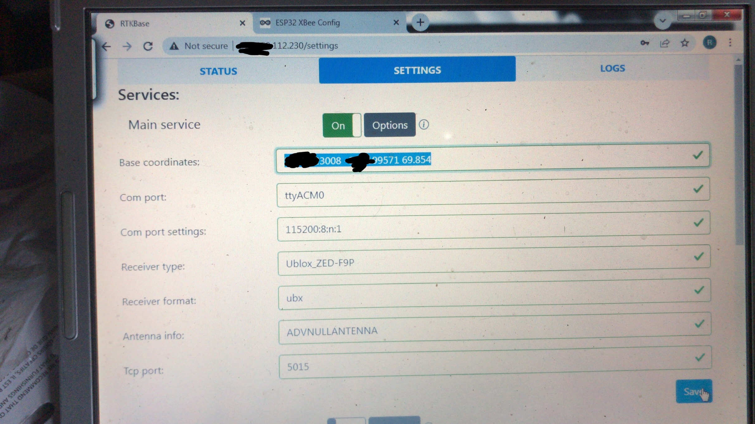
How to enter my fixed position? I hava deg, but x and y are in meters
Whoops, i rather misunderstood that. I was originally using SNIP on a PC to send RTCM messages generated by a f9p to rtk2go and have been using RTKBase to do the same on a Pi instead of the PC, without changing the f9p configuration.
In the fixed position check the “Use Lat/Lon/Alt Position” , and write the fixed lot/lang alt
Things I learned from this.
The biggest problem with achieving an absolute fixed position is not that such a thing doesn’t exist, but that even if it did, it would only be for a moment.
The land itself is in a constant state of flux, it is always moving.
And the Earth itself is a pretty weird shape.
So I think I’m right in saying we don’t seek accuracy, but we do seek precision relative to two fixed points at a given moment.
That is to say…
I got my base station working, thanks ![]()
We could really use an easy to find, standard guide for how to do this.
1 Like
In ucentre you should see something like this:
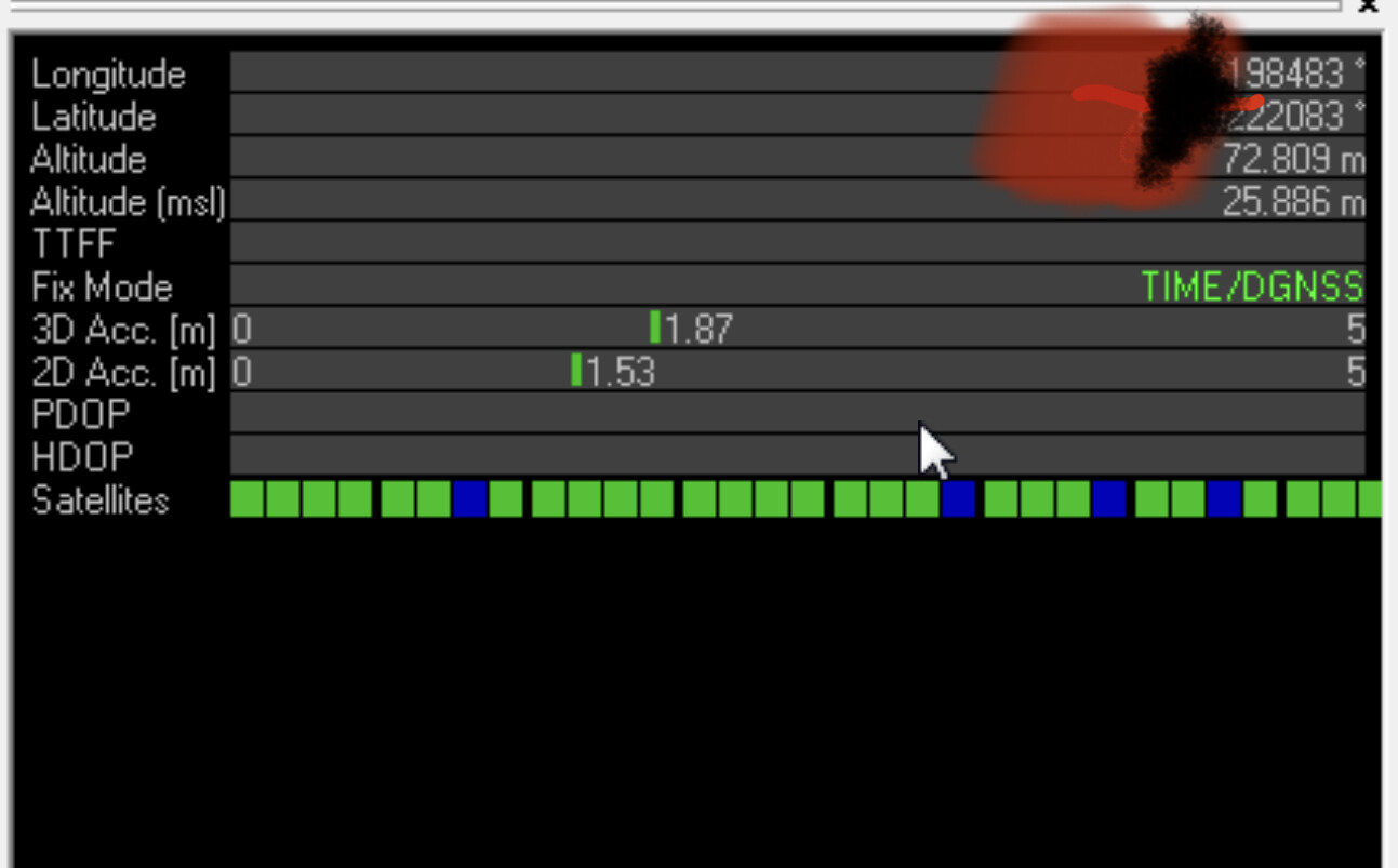
Just note down the Long / Lat / Alt and paste them into here (separated by a space).
2 Likes
Yes, but I have only “TIME”

That’s all you should have
1 Like
That’s why we usually use a plate fixed coordinate reference system, as ETRS89 for the eurasian plate. With this CRS the coordinates don’t change during the time (except for internal plate deformation, but it’s not a problem in UK).
What you see in U-Center when you’re not in RTK, are ITRF coordinates. These coordinates change with time, about 2cm per year for me in France, 10cm per year in Australia. It’s not a good choice.
1 Like
But relative to base stay in place because your base moves with your fields on tectonic plate even as absolute position of base changes with movement your AB lines borders etc stay at same place.
For AOG ITRF are good. But if you care about repeatability use only yours try using other bases correction and see how much it jumps.
One big advantage of commercial RTK corrections is that they are referenced to local plate and you can move anywhere where there is coverage and lines stay in place.
While for your base you get worse performance 25km+ or you have to switch to other base if there is closer base and depending on when that base is set up cords will jump, if you did PPP and that base did not jump can be worse.
1 Like
Yes for land survey you want your local system, I know that land survey without government corrections is not valid hire.
I not familiar with archaeology and how they are funded but biggest project should have negotiated or invested in equipment.
If rtk2b can achieve 2.5cm required vertical accuracy you can always translate cords to different formats and datums with good software.