Hello,
I recently aquired 2 SimpleRTK2B boards (SimpleRTK2B Pro with the wifi module and Bluetooth kit from Ardusimple).
The use case for my project is to generate a 3D topographical map of some of land.
Here’s my setup:
The SimpleRTK2B Pro is set up as the base, I’ve set the TMODE3 to Fixed and used the averaged coordinates I obtained from the device after letting the GPS unit run for a while with TMODE3 disabled.
I’ve set up the base station as per this Ardusimple article: https://www.ardusimple.com/how-to-configure-simplertk2b-as-static-base-station/
The antenna location is static and fixed for the duration of the run.
Averaging the position of the base station antenna is good enough for me, as I am primarily interested in the altitude features of the points rather than their exact horizontal location.
When it runs, the fix on the base station (according to u-center) is TIME or TIME/DGNSS (this seems to change periodically though not consistently).
I’ve configured the WiFi module and pushing updates to rtk2go as well as using u-center to setup a local server (accessible through the internet) for NTRIP corrections.
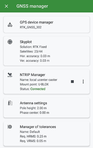
For the rover I’m using the RTK Portable Bluetooth Kit with its default configuration. I connect this to Locus GIS and set up both the receiver as well as the NTRIP service (I tried both the u-center server and rtk2go).
On Locus GIS I get a RTK Fixed solution.
The distance between the station and the rover is around 3km (1.8mi).
Both the base station and the rover have a clear view of the sky.
My goal is to get within 5cm-10cm vertical accuracy for my readings in order to build an accurate 3d topo map of the land.
Here is the issue that I’ve been experiencing as I was doing the topo survey: while the horizontal positioning seems to be extremely accurate, over time, I’ve noticed that altitude drifting upwards as time went on.
For example, starting at one of the corners of the land, I was seeing an altitude of 110.XXm at the highest points when I started the survey.
As I went around taking points, there seemed to be a discrepancy, showing higher altitudes than the initial point. By the end of the 1h30 survey, returning to close to the initial point, I was reading 118.XXm; basically a difference of 7m-8m between the moment I started and the moment I finished.
I’ve only noticed the drift happening upward and didn’t notice it going back down during that period of time, like the altitude was constantly increasing.
Obviously this makes the entire dataset collected during the survey useless since I have no way to correct or know what drift happened at which time to manually adjust the points.
I am not sure what is causing this or how to solve it.
Any help or ideas for solving this issue would be greatly appreciated.
Thanks in advance!
