This is a project in progress.
It’s a ‘workaround’ to give AOG the ability to spray definied spots in a field triggered by AutoSection On/Off. It modifies the Section.txt file and need no code change in AOG. All logic is done in QGis. Please, watch the video to get a idea of.
4 Likes
Good job. So a few questions:
You changed 10,0000 to 4.50000, is this the grid size? So 4.5 meters. x 4.5m. = 20.25 square meters?, and how do you create the areas that are not sprayed for spot spraying? drone view, satellite view, multispectral camera etc.?
Awesome !
How do you determine the areas to spray?
A manual survey in the field?
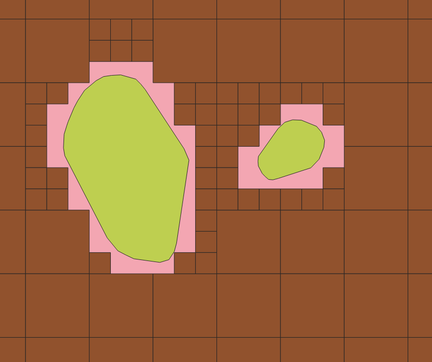
Here you can see the small squares and the bigger one. Green is the spot you want to spray. Pink is additional area due to the square pattern, depending on small grid size. Red is the area that we write in the Section.txt file and is shown in AOG as already worked (mapped). Not worked area triggers Auto Section On. Every square needs 6 lines in the Sections.txt file. That’s why we introduced two grids, a bigger to keep the Sections.txt file small and a small grid to get some kind of accuracy (but keep the section width of the sprayer in mind). The bigger grid size has to be an integer multiplier of the smaller.
1 Like
Yes, a manual survey in the field with an android mobile phone with ntrip correction by lefebure app. Hardware is powerbank powered ardusimple f9p board connected by bluetooth. For now we have only recorded two fields. Maybe the community has ideas for better practice.
2 Likes
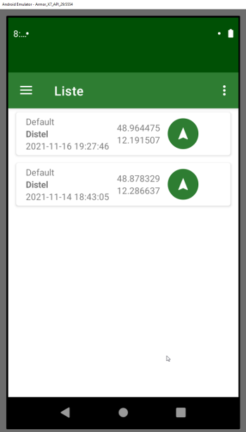
For a little demo on the android app we use to record the spots see below video; it’s just a brief demo on how an area is recorded

3 Likes
Project is also on Github - work in progress ![]()
2 Likes
Great app!
1 thing that I would see on an application like this, maybe it can already do it:
To be able to pause the recording of the spot, while exploring the surroundings and thus be sure not to miss a part.
And obviously availability in English or even in French ![]()
And where and how can I get this application?
Thanks!
When you stop the recording, the record / GPS points are written to a database in the app. and you can turn on the recording again, generating the next spot. spots can also overlap, so it is not a problem to pause in between.
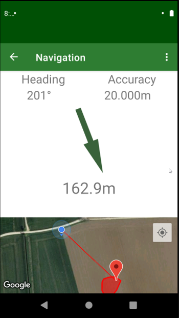
We also built a “navigation option” to navigate back to a previously recorded spot if you want to find it again.
A first running version (at least on our phone
But I think you would need the F9P GPS setup to run this properly, with only a phone the GPS signal is not accurate enough. Maybe @Wolle can say some words on the hardware setup.
5 Likes
provided also a quick-n-dirty translation to English; French is far beyond my skills ![]()
1 Like
I like it ![]()
If you want help for french, please advice!
Great idea, GREAT work