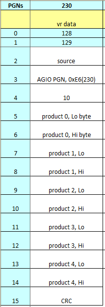
Could you explain how to use the pgn address? the first 4 numbers are the address but the other what are standing for?
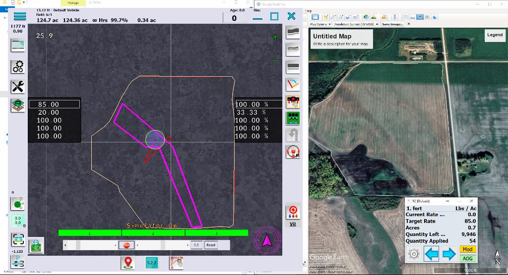
This is close. The products are percent of the maximum x 100. So we get 9500 that is 95 percent. 6745 = 67.45%. In the rate planner, it gives you the maximum for that product. On the main screen, the percents on the right is what it is sending out, times 100.
I was thinking about how to convert a currently mechanical fertilizer spreader with two openings to a variable rate, I came up with two ideas:
- use two large servos.
- use two linear actuators and two potentiometers to know the opening.
The problem is that I do not know how to set the rate controller for these two solutions, not having a flow meter or a speed sensor to monitor the real flow it does not activate the spreading.
I know that without a monitoring system, like a weight scale, the controller can’t monitor the flow, but the ratio between opening and flow would be imported from the spreading chart.
@SK21 any ideas?
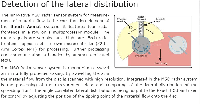
Actually, there are solutions for fertilizer spreaders, but unfortunately they are expensive, I saw the products in the picture in Agritechnica and they were awarded. Since the weighing system will be in constant motion, it is very difficult to get average values, in my opinion, the cheapest option is to start the pto by removing the ejection discs of the machine and placing a bucket under it, and to create a new scale by weighing the amount of fertilizer falling on each scale. (even if the fertilizer has the same characteristics, the weather conditions and the differences arising from the fertilizer seller will change the volume and density of the fertilizer) The rest is to use Linak brand internal potentiometer or a linear motor with hall sensor, the rest is a little programming knowledge…
Sorry for the bad english.

My problem is not how to calculate the flow, but how to make the SK21 rateApp open-loop, that is, without a flow meter or encoder for motor speed.
I can map the opening of the gate to a specific location in arduino/rateApp and, based on the spread graph of my fertilizer spreader, set the corresponding flow on the product page in the rateApp, but without a flow meter/ecoder/sensor, I can’t get the app to work
So to measure the flow rate you want to convert voltage from a potentiometer based on the ratio between opening and flow. This could be done with another control type option, maybe call it Gate Opening. The calibration number would have to be changed to Units/Volt. You would need to use an analog pin on the nano or a ADS1115 connected to the I2C header. A motor controller could operate the linear actuators the same as a flow valve.
I am not convinced that units/volt is correct, in my opinion the opening is not proportional to the flow (also calculating the various levers) maybe a table / mapping would be better?
How large a table would be needed? 10-15 entries?
I think they are enough, the manual adjustment of my Amazone goes from 0 to 15😅
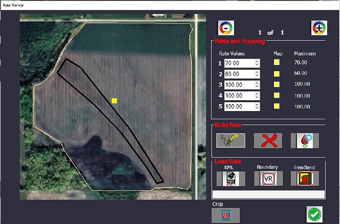
Just tried the vr mapping. It works really well. I can see your point about sending the max rates. It would make the whole thing more seamless and easier for the user if the max rates were already there. The base rate could still be entered in case of missing vr data. The user wouldn’t have to match up max rates with selected stream. In the variable rate combobox the rate # and max rate could be shown.
I noticed when the boundary rates were saved, they were saved to a different map, not the boundary map.
Also need to add the Rate Planner into the Help manual.
Is it possible to draw a rate map over a google image of a field. On the map I drew a rate zone for a sand ridge I can see on the google image. It would be much easier if it could be drawn right on the image.
I just tried this as well. Just so I understand, this is integrated into AOG not like Rate control that runs seperate?
Also I am a little confused about 5 rates and also the the % on the right side. Are these 5 rates for one product like one tank of my drill? If I am trying to control multiple tanks how do I add more layers or rate layers?
This looks really nice, good job to all involved
There are 5 rates in each zone. You can add as many zones as you like. You can choose which rate stream is for which product. The % on the right is what is sent to RC. It is a percentage of the maximum rate for each stream. For example if you have 3 zones each zone would have a value for the first rate stream, say 80, 100, 75. 100 is the maximum and the other rates are a % of it.
To add a zone draw it first then enter numbers for each stream on the Rate Planner page, then save when finished for that zone. Draw another zone, edit and save the numbers. Scroll through the zones with the - and + at the top right of the page.
It is integrated into AOG.
Two options:
Draw it in GE and save that to a kml and import that kml into rate planner and then set rate.
Set up field as normal, boundary and all. Close AOG. This will build the field.kml. Open this file with GE. View all objects in the field (left menu.) There will be a thin red line drawn way outside the field. Set the zoom to fill the page. Press U for up, and N for north. Save screen or image. (Alt-PrintScreen) Open paint software. I like Paint.net. Right click-paste. Crop image to that thin red line. Export as JPEG file and remember where you put it. Open AOG, Open the field again. Then click the little out of place map on the lower left corner. Click Load Image. Navigate to that image. Open. You should see the image. Save. The field will be the background if everything was right. You will be able to see it in the VR planner. Good Luck. it is a lot of steps and each has to be done correctly.
But to get the actual values, you must use an external like Rate Controller.
The 5 rate values are specific for any location in the field. The rate areas (contour/topo lines) are equal rates areas. Takes some planning with multiple values of overlapping areas.
Ok, just so I am clear. Each rate would represent a tank that I would be controlling. So if I have 4 tanks being controlled I would have 4 rates for each zone? The zones represent the different areas of the field? Does that mean the zones for all the tanks(products) being controlled would be the same.
The rate areas (zones) do have equal product. If you need to modify a product in a zone, create an interior zone or split the zone.
Another way to say it:
A large area in the field gets a prescription of rates 1,2,3,4,&5. If you draw another circle inside that one then it gets a different prescription of rates 1,2,3,4,&5. If the prescriptions overlap, it will pick the smallest area and apply that prescription. So watch overlapping the prescriptions. You can set the whole boundary to a prescription and add smaller ones inside. But if you are going to import a kml file, do that first.
