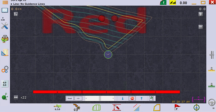
I’ve been trying to make a variable rate workflow but I keep getting stuck on creating the bmp image in AgOpen. I’ve used Tony’s v6.3.0 and the official v6.3.3.
When I hit the % icon, it generates the correct .bmp file, but on the GPS display I see ‘Red’ in big red letters painted across my field. I don’t get the map overlay.
Exporting a .bmp from QGIS and saving it as RateMap1 doesn’t replace it either.
What have I missed?
Try this: 14. VR Maps · SK21/AOG_RC Wiki · GitHub
I still don’t get any kind of field overlay.
Even just creating the map in the AppMap window, closing the field, closing AgOpen and reopening it all without editing anything yields nothing.
Is “Red” your image? You can’t have map overlay and the rate image, it’s one or the other.
I haven’t even got as far as substituting the image yet! See video below.
dropbox
Maybe something to do with being in Europe is affecting the app map. Is the correct field shown in the png?
Looks like there’s some old code crossed up there somewhere. Did you try make a new field rather than “from existing”?
The word red is being generated / used from somewhere
I’ve just made a new field in simulator (start location 51.07, -3.11) and it’s still displaying ‘red’ when I press the % button.
I then pressed the ‘reset everything’ and made a new field in Brian’s back garden (default sim start location) and I get the same.
The generated .bmp is in the right place every time
I want to get the M1A and M1B signal from cytron on the amp 23 connector ? Do i have to connect the MA and MB from cytron with M1A and M1B in the left of the ads 1115 position to get this going ?
Yes that is correct.
I’m using V3.7.15 of rateapp with RC11 and the separate (dual) auto doesn’t seem to work in auto section. The relays are on all the time, even when crossing painted area. The master and section switches work like it is in manual. Screen painting is correct, but the relays don’t switch off.
It works as expected when using the ‘classic’ single auto. Is there something else to enable to run with the dual auto?
It was a bug. See if this version works: GitHub - SK21/AOG_RC at FixAutoSection
Yes, that works. Thanks for the quick update and all your time and effort.
Hello
I recently mounted AOG on the tractor. Now I want to equip my sprayer with SC and RC. I have read a lot here and also looked at the Github. Unfortunately, I still don’t understand how it works exactly and what I need.
I want to equip the sprayer with a new ARAG fitting. So that I don’t need a spray computer, I want to control the quantity via AOG RC. It should be speed-dependent. However, the quantity control should also be possible manually just by pressure control without AOG. I have seen that there is a SwitchBox and various RC boards. I want to be able to switch 5 sections.
Which ARAG fitting works well with AOG RC?
Which boards do I need for 5 sections?
What is the difference between ESP32, Nano and Teensy?
Where can I find the Gerber files for the boards?
Sorry for these beginner questions and my bad English
All the boards can do 5 sections. ESP32, Nano and Teensy are the micro controllers used on the boards. The ESP32/RC15 board would probably be best for an Arag sprayer. The sprayer can be manually controlled without AOG. The gerbers are here: Rate_Control/ESP32/RC15/jlcpcb at main · AgHardware/Rate_Control · GitHub
Thank you for your answer. Now I know where to start. I still don’t understand how the switch box is connected to the RC15?
Is there also a switch box that can switch 5 sections?
The switchbox is connected to the tablet over ethernet. Each switch on the switchbox can control more than one section. Someone has made a board with more switches.
Hi, not sure if I’m doing something wrong, when i try to order RC15 or 11 on JLPCB the website show s an internal error after I select to process the BOM and CPL, can anyone help/have seen this recently?
It may be the site. Try again later.
How difficult would it be to add a pulse per second output to the app in addition to PWM? I have been kicking around the idea of driving the seed meters on my corn planter with stepper motors, so it could be utilized with your rate control app for variable rate seeding and individual row shut off. If it’s not easy to add I thought of trying to utilize an arduino to receive pwm signal from the rate control board and then in turn converting that signal to a pps value.
