![]()
![]()
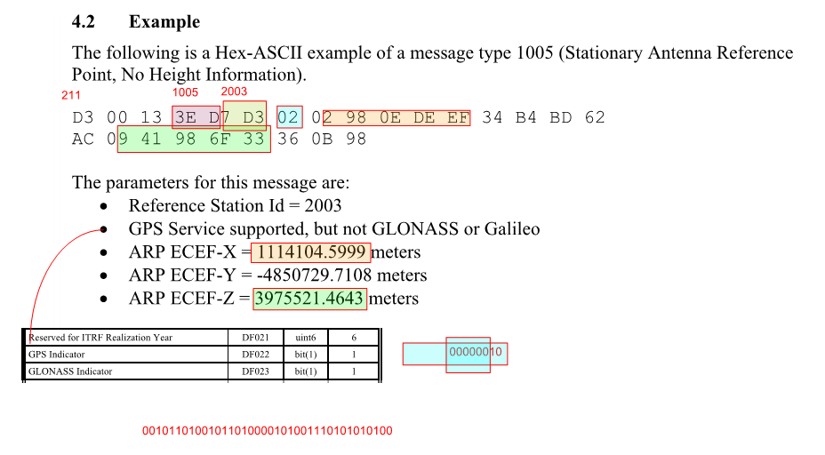
12 bits three groups of 4
But does one bit come as one bit or is there spaces, I don’t know.
11010011 = 211 and also = D3
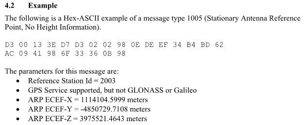
D3 = 211
00 = 0
13 = NOT SURE
3ED = 1005
7D3 = 2003
Then I get lost.
![]()
![]()
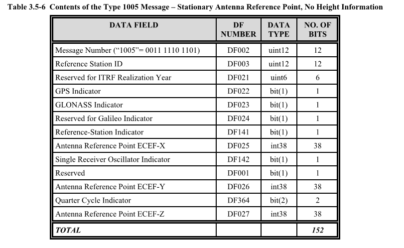
12 bits three groups of 4
But does one bit come as one bit or is there spaces, I don’t know.
11010011 = 211 and also = D3
D3 = 211
00 = 0
13 = NOT SURE
3ED = 1005
7D3 = 2003
Then I get lost.
Without conversions meaning in binary? I believe it had an option to display as binary I can have a look at that when I get a chance and post it here,
Yes, I think binary.
Here is the link for the serial port monitoring software I used, I think it’s free for the first 14 days or something like that. If you wanted to try it out.
Sorry, is there a manual or a step by step guide for this, even a rough one? Thanks
A little update
I finally managed to add NTRIP to Opengrade.
Also Opengrade and Opengrade3D can now parse PANDA sentences.
But still only serial(USB) ![]() ,
,
Building this UDP stuff is above my stills.
I hope make a video about OpenGrade/OpenGrade3D eventually, to explain which app does what, since this project lacks documentation! ![]()
Any changes in proplever.ino? If yes, what?
I will have to check for these inos! In august I dated more values for the communication in OG3D. I don’t know if OG have the update.
Either the one in the separate zip or one in the support file should work.
I will have to check in the next days!
What troubles are you having with UDP?
I just have no idea how this should be done(in the code)!
Also I don’t know which route would be the best.
For how it can be just USB, no special hardware needed, just plug the GPS and controller.
Easy for newbies to give a try to the software!
Maybe working trough AgIO would be nice, or wireless.
I really like the idea of just basic ethernet with the flexibility for each device to choose UDP or Serial.
I have no training in coding. I’m just copying/pasting, nothing to paste for UDP!
The NTRIP addition in OG3D was done by @nut .
Once again I just pasted to OG yesterday, wanted to do for a while but it looked complicated.
I Gave it a try, took 5 hours and some Google searches!
I also have no training in coding, and up until about a year and half ago I had never read a line of code. but there is a lot you can learn from YouTube! But I agreee the ability to plug right in without any special hardware is a big positive for newbies.
Hello everyone. Im trying to test if this software will work for our needs. ive gotten a simulation software (5.6.2) to see but i am having issues working with .xml or even finding the grades options to use .xml made from Carlson software. any help would be highly appreciated.
Nice! I am wanting to build a system. Having a bit of trouble finding beginner info. Where is latest version on GitHub? Not ready to go wireless yet. Would b cool later. Thanks
most are using pat V2.1.3 i think. I have not yet used his latest that has N-trip cababilities. Nor have i used black aces OG x, although i plan to build one for testing. Whichever way you go its a great system.
Is there any way to create a visual altitude map out of the .ags file from open grade 3d without using Optisurface or similar expensive softwares?
.ags file are in a standard text format. You can change the extension to .txt and open with a lot of softwares.
QGIS is a popular one that could do the job but I never used it.
In Google earth pro it’s easy to import and have points with the latitude/longitude but not sure can create a visual altitude.
Thanks! Managed to create a map with QGIS. And is there any option to Optisurface for creating an .agd file out of the .ags file? What kind of information does the .agd file contain?
The .agd(design) file is basically a text file like the.ags(survey) but with the design elevation and cut/fill added.
See this post 370 for an example file.
The file must have:
A head line
A benchmark, 0MB
Optional subzones, 2xxx
Optional perimeter pts, 2PER
Design pts, 3GRD,
Latitude (deg), Longitude (deg), Elevation Existing(m), Elevation Proposed(m), CutFill(m), Code, Comments
46.50541598, -72.34992609, 30.324,,,0MB,
46.50388243, -72.35223691, 30.324, , ,2SUBZONE1,
46.50539030, -72.35000354, 30.302, , ,2PER,
46.50541232, -72.34994387, 30.269, 30.249, -0.021, 3GRD,
Can QGIS create and output a design in some kind of text format?
Modifying the OG3D source code to read an other format is relatively easy.
")