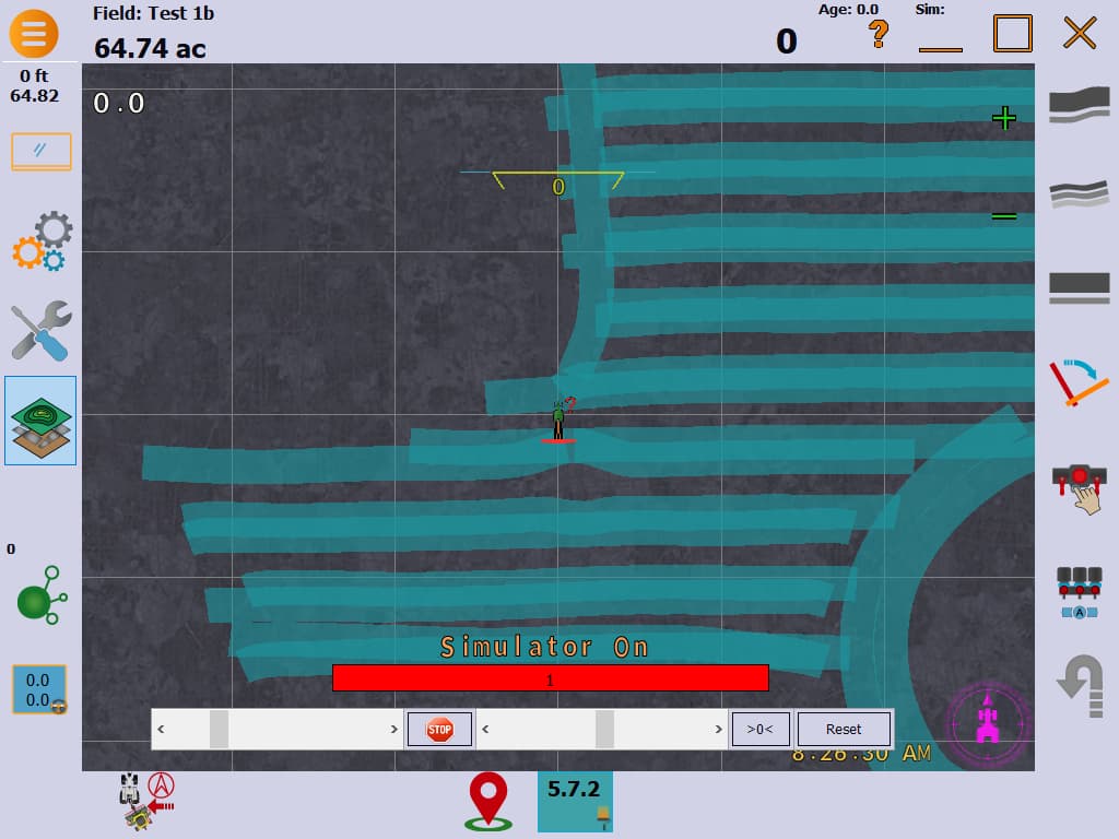
What’s showing on map whenever I follow an AB line is the tractor following edge of last mapped pass and a partial overlap of that pass. The tractor should be shown at half the equipment width out from the edge of the last pass where I’m actually driving.
My equipment is identified with the correct width and pulling from the center of the tractor pivot. I’m not using autosteer.
Probably an easy fix but I cannot seem to find the solution. Any help is appreciated.
Could you post a screenshot of AgOpenGPS?
We see your screenshot.
How did you manage to do this curve correct?
Please show a screenshot where you drive in real life beside an ab line (showing your overlap)
I was going to mention that it worked when I traveled around the trees and sloughs. Good you noticed. Don’t know why it worked there then when I went back on AB lines it overlapped.
Won’t be able to get another screen shot til tomorrow.
I was seeding so I was able to drive a relatively consistent distance (half equipment width) away from last colored path. As I moved forward a rear path was mapped with half overlap and half new. The gps receiver indicator on tractor was shown to be following the edge of the last pass even though the tractor was actually half equip width out from it.
Since it worked correctly on the curve contour and not on the AB contour there may be a setting that I’m missing on the AB line setup.
Did you drive in same direction, where it looks to be working correct?
Yes I did
Are you using single or dual GPS?
So driving in same direction, does not mean the painting of where you had been driving, actually is precisely behind tractor.
I think you have no WAS connected which will put painted track a bit to the side, because AOG think you steer full left all the time.
We know just a few degree off center WAS will paint (or steer some centimeters) wrong
You told in first post, that you are not using autosteer.
You could put some offset to account for missing WAS, and make painting fit.
I’ve set it for single antenna. Does that mean single gps?
Yes, that means single GPS. Dual has it own set of setups, but that must not be the problem. You don’t have an offset in the GPS settings do you?
Are you using RTK?
It looks like an antenna offset
Okay upon looking at single antenna settings I noticed the “Reverse Direction” button was green meaning applied. And for reverse direction there’s a 70/30 split on the IMU vs GPS. I don’t know what the imu means but I’m thinking having this applied might explain why driving in reverse direction overlaps while double pass around trees in same direction works good.
Does this sound like a probable correction to the problem? Will test it later today.
I didn’t know about IMU before this. So from what I’ve just read, the reverse direction is obtaining most of its mapping signals (70 %) through IMU (program calculations based on previous paths) instead of GPS. Logically the IMU would use the previous path (ie the edge of the last path) since this is the best information available. Is this somewhat of an explanation about IMU?
Inertial Measurement Unit has no clue what your position is, it just knows what direction you are headed, and the roll and pitch of the tractor.
Imagine a blind guy navigating a park he knows well. When he finds a landmark he knows that is the GPS position, a defined point but no direction.
But from that point the blind guy can navigate to his next point, using his feelings of internal direction that is the imu.
Are you using rtk? Did you do every second pass then come back with just dgnss?
Didn’t use RTK.
I suspect every back direction on an AB line pass would use the IMU.
Does your tractor properly drive along the same AB track in both directions?
Did you create your field on site or in simulator?
Did you skip passes? Then come back?
Or were you immediately doing the next pass beside you?
I’m not using autosteer. The mapping in reverse direction is misplaced by half equipment width.
I created the field on site.

