had a question, that evolved into a possible bug report…
I noticed some issues with the rinex conversion data, but after updating from 2.3.0 to 2.3.4 i found another issue trying to debug stuff.
so the first issue: in my 2.3.4 installation it seams that the file achieve function creates faulty zip archives in my setup after the update. the Rinex conversion fails, win10 explorer says the ziped .ubx file is faulty, error 0x80004005, and 7-zip cant extract the file either… (I believe i have default file settings) ((the files are fine before archiving))(((And it worked before uodating to 2.3.4)))
Just me or my installation or can anybody confirm?
The other issue I noticed, is that I believe that the Rinex conversion of my logged data does the ‘initial position’ conversion erroneously. When uploading to the Canadian CSRS service, its reporting file (PDF) says my preset position is at 79m height but my setting is 69m. (as the GPS also is showing). I’ve tried to confirm the numbers through various conversions, and as i understand it RTKBase Rinex conversion does something strange with these numbers… (although after some study, I now have realized the complexity of these coordinate transformations, and the many pitfalls of various reference frames and so on…)
this is of course no showstopper as such… i just got confused why the numbers in the PDF-reports did not made sense…
Any input upon this issue?
And a final clarification the GPS position on the webgui map. Is this the latest position from the GPS unit ? Or as i now later have realized, is this a position calculated from multiple readings run through RTKlib to estimate a more precise position over time? (Btw, It would have been nice with some kind of length reference presented in the map or in textform, to be able to judge the current reading in relationship to the specified base point. )
any way…
Thanks for your efforts into this project Stefal
BR /Klas
27 april Uppdate on the zipfile issue… updated to to 2.3.4 on the 23 april… generated zip file on the 23,24,25 are all erroneous. File from april 26 worked ok to convert…. (No changes on settings or reboots)
Does it make day file time 23:59 or what? today i left my fully assembled station running and put on file logging. if i want to make rinex with rtkconv and use canadian post processing tomorrow do i get accurate enough results?
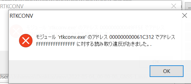
I’m getting this error when I try to convert to RINEX in RTKBase. Any thoughts?
Failed!
caution: filename not matched: 2022-04-29_00-00-00_GNSS-1.ubx 2022-04-29_02-32-28_GNSS-1.ubx 2022-04-29_02-32-57_GNSS-1.ubx rm: cannot remove ‘2022-04-29_00-00-00_GNSS-1.ubx’$‘\n’‘2022-04-29_02-32-28_GNSS-1.ubx’$‘\n’‘2022-04-29_02-32-57_GNSS-1.ubx’: No such file or directory
I was wondering, if it is possible to somehow get the positions of the rovers?
They sent nmea back to caster, so is it possible to access it with RTKBase/RTKLib?
I DO NOT THINK, The RTCM TCP option does not allow to receive the position of the rover through a nmea messagen but to transmit the RTCM messages from the base to the rovers directly through a TCP internet connection without the need for a caster
I know little nothing about the rtkbase project, but the NTRIP protocol supports both RTCM out to rover as well as Sending fix positions back to the base from rover over tcp. I believe you just have to send a different authorization string to allow the caster to Poll your rover(using HTTP). Although without sitting in front of my computer I can’t say for sure.
I sniffed the packets on rtkbase and if I set send gga every 2 seconds in Agio I get every two seconds a bigger package. But if I display it with tcpdump I only see ASCII garbage. So I don’t know how to decode. Thought it is nmea and I can just read it… But no
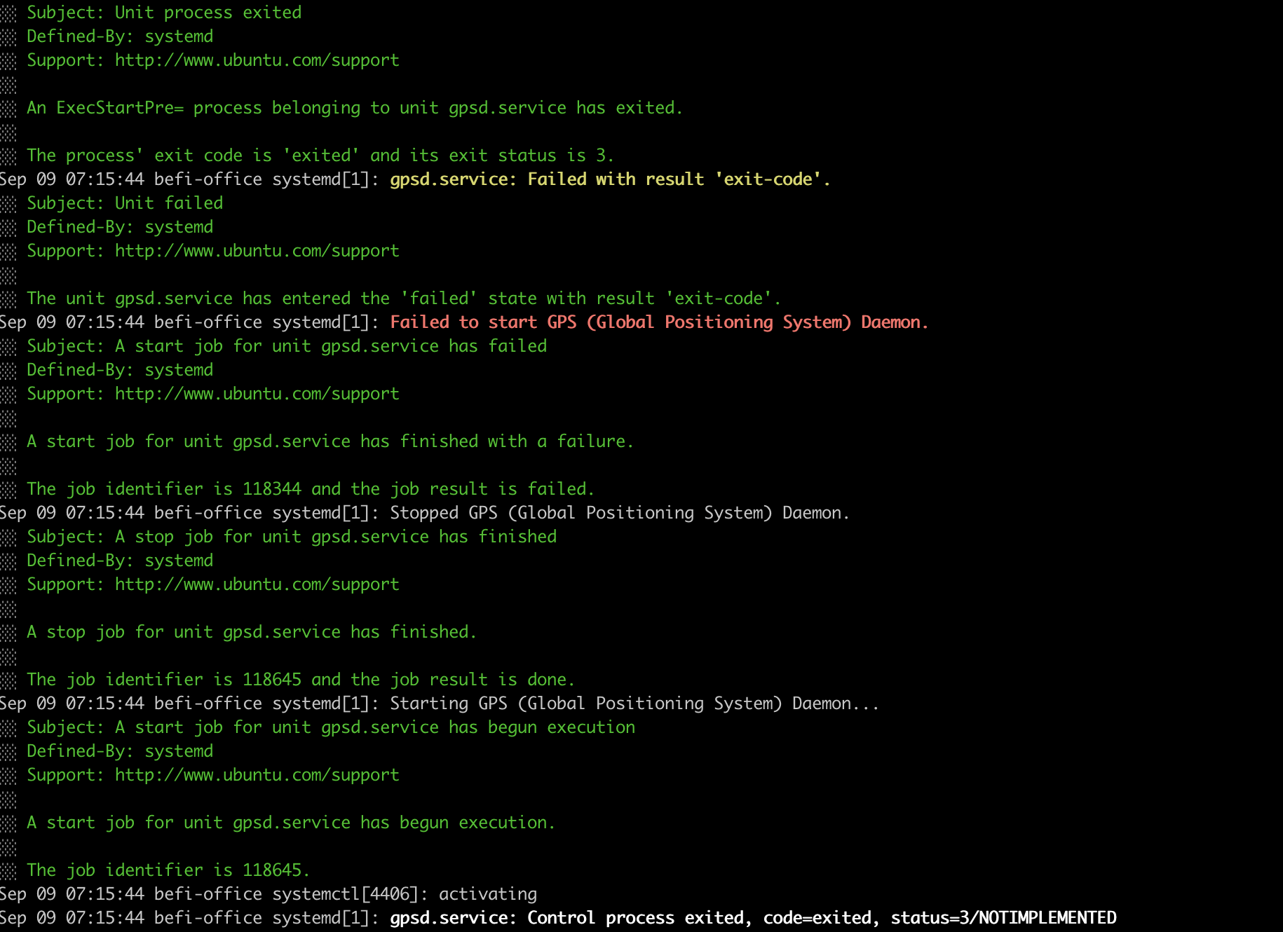
We area making an automated positioning system for sea containers and are using Ardusimple (ZED F9P) RTK systems. Base-Rover seup over radio didn’t work for us because the container piles block the signal.
So… We decided to build our own NTRIP caster server. We have an old HP running as server running Ubuntu 22.04LTS. I followed the RTKBASE setup guide but for some reason the gpsd.service fails.